
Tag Archives: Maps


What is geography?


Neighborhood Maps
21 Nov Here are a few of the many great maps that were created for our Out of Eden Learn Project. We hope you slowed down and explored your neighborhood and noticed new things about where you live. As we prepare to begin our unit on settlement, we hope this was a good activity to help you think about where you live. The purpose of this activity was for you to think about your own relationship to a place. It is also a chance for you to share more about yourself! We are also happy to have our guest speakers, Balajee and Karthik, come to our class to talk about the history of Chennai and how it was settled.


The Problem with Maps
7 Dec
This is a pretty cool video that I saw recently. Sanjeev also saw it and sent me a message about it. Check it out! “There’s not “right” map projection. Each comes with trade-offs, and cartographers (map makers) make projection decisions based on the particular tasks at hand. But if you are interested in seeing an accurate depiction of the planet, it’s best to stick with a globe.”
Cool Maps – Population Growth
28 Nov
Mr. Jet shared this map on Twitter and I thought it was cool. World Population History is an interactive map and timeline of the world’s population growth from 1 C.E. to today. The map is essentially a heat map of population centers. The timeline at the bottom of the map features little place marks that feature developments in science, trade, and major political events. You can click on the markers in the timeline to learn more about each development. Check it out!
Creating Neighborhood Maps
23 Oct Photo by Rob Martin
Photo by Rob Martin
Photo by Rob Martin
Photo by Rob Martin
Photo by Rob Martin
Photo by Rob Martin
Photo by Rob Martin
Photo by Rob Martin
Photo by Rob Martin
Students have finished Out of Eden Learn, Footstep #2 – Creating a Neighborhood Map – and written a story using one of the five prompts provided by Out of Eden. Here are is a sample of some more of the maps that were created. After Week Without Walls, we will share the maps in a Gallery Walk with our classmates. Click on the images to see a slideshow.
Geography of China
9 Feb“China is a sleeping giant. Let her sleep, for when she wakes, she will shake the world.” – Napoleon Bonaparte
This week we being our next unit on ancient Asia, China. Over the next few weeks we will learn about many new things about ancient China using our historical themes, or what we often call GRAPES. We begin by learning more about China’s geography. See Do Now #13!
What are the physical features of China? Use your textbook, library books in the classroom, the maps below, and the videos to help create a list of the features and what makes China unique. The British Museum also has an excellent link on geography in China (Story – Explore – Challenge).


Footstep #2 – Neighborhood Map
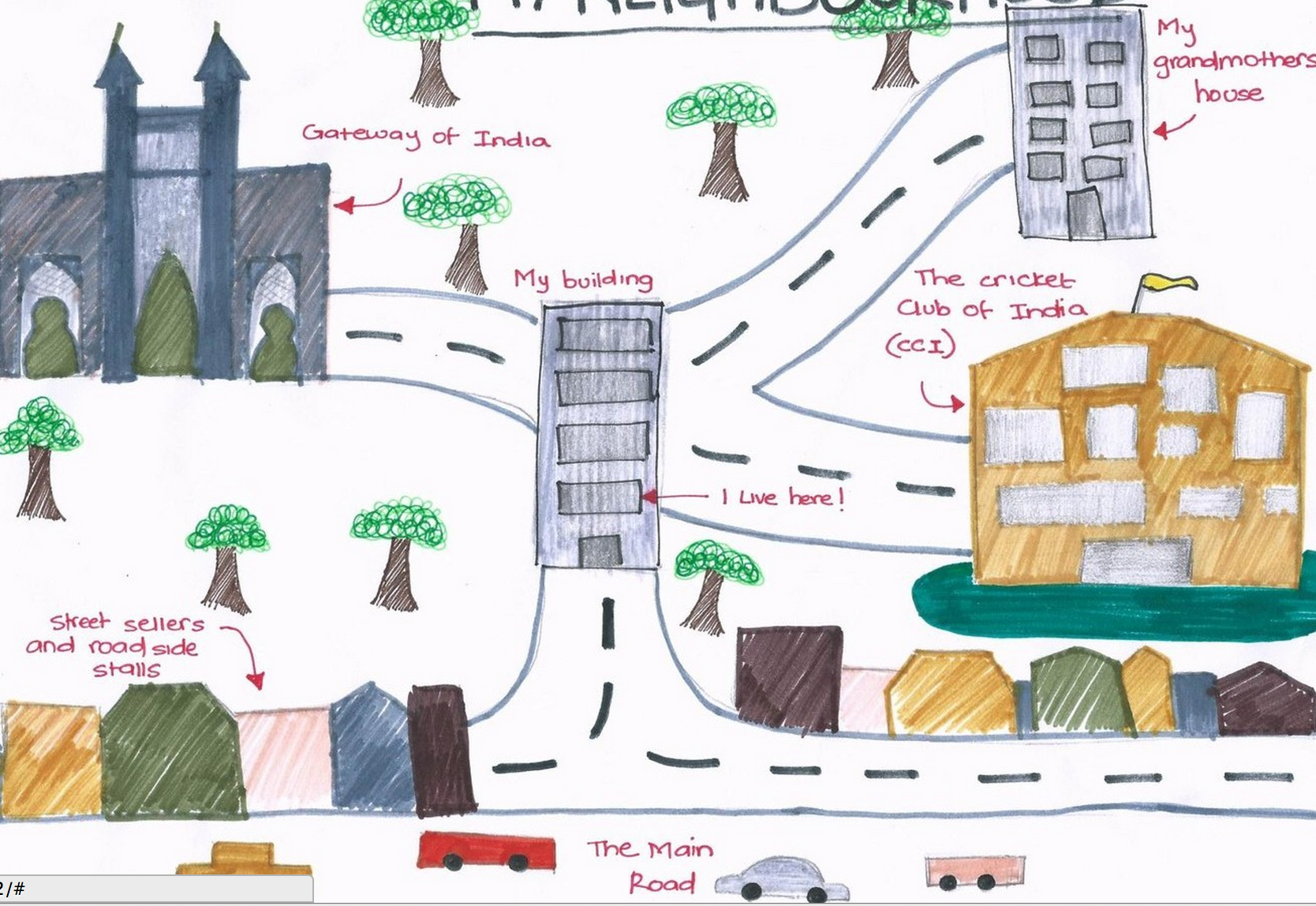
14 OctThis week we launch Footstep #2 in our Out of Eden Learn project. Students will learn what a “milestone” is in the Out of Eden Walk, and they can look at some of Paul’s milestones during his journey in part #1 in Footstep #2. The first project for Footstep #2 is to create a neighborhood map and to write a story about your neighborhood or the area where you live.
Directions for the project will be shared in class and they will be posted on our Moodle page by tomorrow. The due dates and expectations, along with a rubric are in on the document in Moodle. Please look at some of the examples from other students in our walking party. They may be a helpful model as you prepare your map ands story. Remember to write the rough draft of your story on your Out of Eden Learn Google Document. I found a link to old photos of Chennai (Madras) on this link. Check out the pictures, old maps, and art.
Old map of Chennai (Madras)
Your Out of Eden Walking Party
3 OctB/D Walking Party Map (click on the map to make it bigger)
G/H Walking party Map (Click on it to make it bigger).
Students,
This week we will complete our first ‘footstep’ for Out of Eden Learn. Click on the maps above to see who is in your walking party. I have also created a Google Map showing your party.
B/D Walking Party #564 – United States (Buffalo Grove, Illinois; Miami, Florida; Saco, Maine; Danville, California; Marblehead, Massachusetts), Riyadh, Saudi Arabia; Accra, Ghana; Burlington, Ontario, Canada, Bandung, Indonesia
G/H Walking Party #565 – United States (West Hartford, Connecticut; Durham, North Carolina; Kamuela, Hawaii; Danville, California; Anchorage, Alaska; Saddle River, New Jersey; Buffalo Grove, Illinois; Marblehead, Massachusetts), Dar Es Salaam, Tanzania, Accra, Ghana
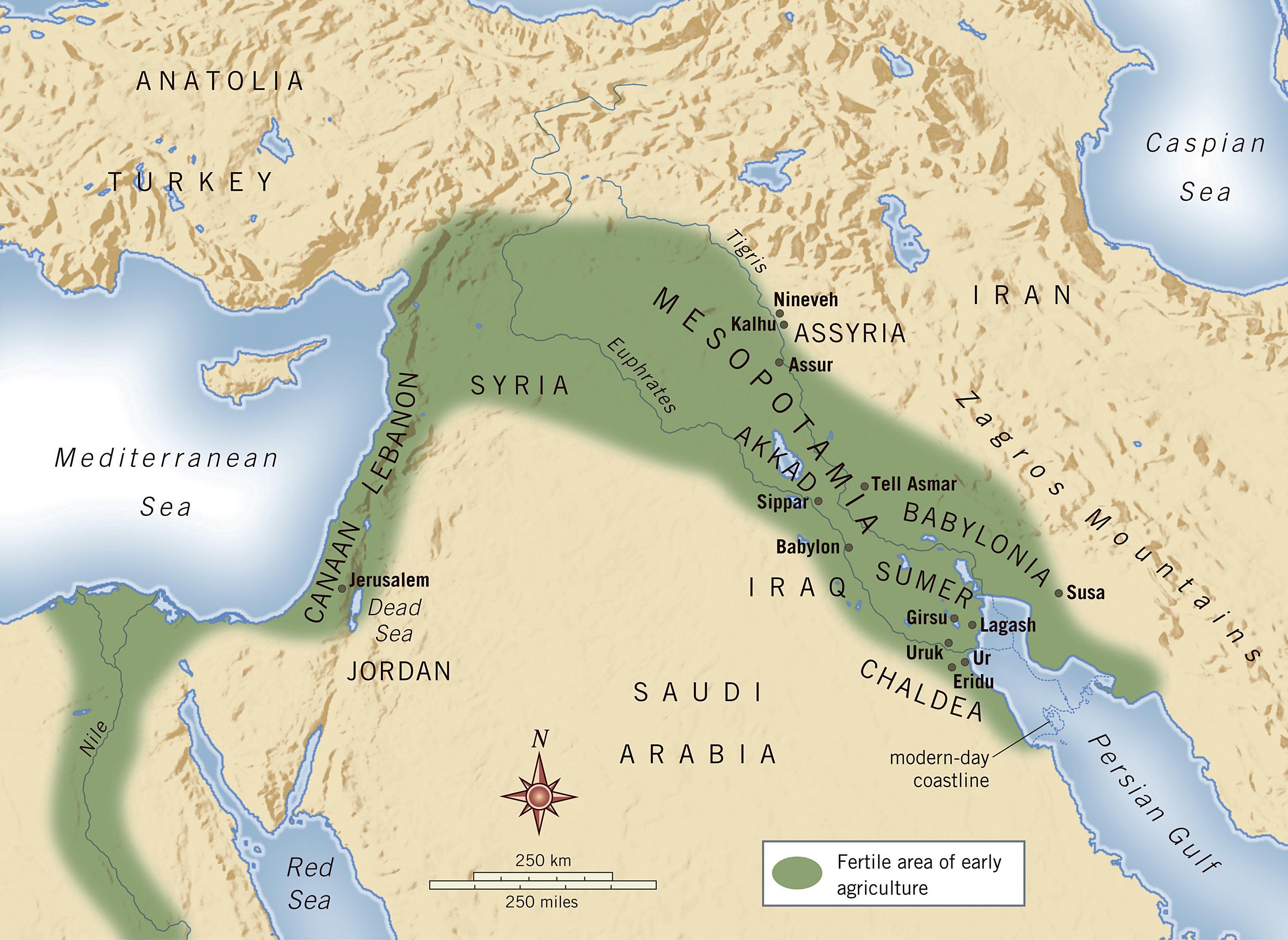
Where is Mesopotamia?
15 SepMesopotamia
Tigris and Euphrates rivers
The Fertile Crescent
Modern day Middle East map.
Screenshot of Euphrates River from Google Maps. You can see how fertile (green) the land is near the river (vs. the desert).
Screenshot of Tigris River in Iraq from Google Maps.
Mesopotamia is a name for the area of the Tigris–Euphrates river system, corresponding to modern-day Iraq, Kuwait, the northeastern section of Syria, as well as parts of southeastern Turkey and of southwestern Iran.
Neighborhood Map Celebrations
26 Mar

“…To me who lived in South Korea for 11 years, India was quite new to me. Everything was new, such as roads, buildings, and people…” – Out of Eden Learn student, Cookieman (Yoobin), Chennai, India.
Tae Yeon’s Map
“When I leave India, I am going to make a long video of me walking in my neighborhood. I am going to remember this place,” Out of Eden Learn student, Howlingwerewolf7 (Tae Yeon), Chennai, India
Yoobin’s neighborhood map was selected as the new cover photo from the Out of Eden Facebook page. There are over 700 schools (think approximately 20-30 students per school!) involved in the Out of Eden Learn project. It’s quite an achievement to have her map chosen among all those schools. Congratulations to Tae Yeon too. Her map was selected for the Out of Eden Learn Instagram page.
We got this message from Out of Eden this past week after sharing our work:
“I hope this email finds you well. I just got back from a week away from the office and had an opportunity to check out your blog and the gallery walk your students participated in. Amazing work! They seem really engaged and their maps are beautiful. I can tell they spent a lot of time and effort on their projects. Thank you for facilitating such inspiring work!” – Sheya, Out of Eden Learn
Neighborhood Map Gallery Walk
16 Mar Due to MAP Testing this week, we had to postpone our gallery walk to Thursday and Friday. We will have some special guests coming to our classes to see your project. You need to be prepared to talk about your map and the Out of Eden Learn project. Here are some things you need to think about before this activity.
1) How would you explain Paul’s journey or the Out of Eden Walk?
2) How does your map relate to what Paul is doing?
3) What is something new or interesting you learned about your neighborhood through this activity?
Please make sure all maps are turned in by Wednesday at the latest and add your story to the document we shared with you. Some of you need to make small revisions to your story.
Creating a Neighborhood Map
27 FebOut of Eden Learn student shares a detailed neighborhood map from Mumbai, India (Image Source: Out of Eden Learn)
Out of Eden Learn student shares a detailed neighborhood map from from New York, New York, United States (Image Source: Out of Eden Learn)
Out of Eden Learn student shares a detailed neighborhood map from Canada (Image Source: Out of Eden Learn)
Out of Eden Learn student shares a detailed neighborhood map from Lahore, Pakistan (Image Source: Out of Eden Learn Facebook Page)
A neighborhood map by Out of Eden Learn student in Illinois, United States
A student example from Mumbai, India (Image source: Out of Eden Learn blog).
This week we launched Footstep #2 in our Out of Eden Learn project. Students learned what a milestone is and looked at some of Paul’s milestones during his journey. The first project for Footstep #2 is to create a neighborhood map and to write a story about your neighborhood or the area where you live. Directions for the project were shared in class and they are available on our Moodle page as well. The due dates and expectations, along with a rubric are in on the document in Moodle.
Are You a Power Puncher?
24 FebOver 700 schools on Out of Eden Learn
Photo by Paul Salopek (Image source from Out of Eden Walk Facebook Page)
This week we will start Footstep 2. Before that, we will reflect on our writing and blog posts for Electronic Oasis. Are your reflections shallow or deep? What is a shallow or deep reflection anyway? Our goal is to help you to become a stronger reader and writer, one who makes deep reflections where you ‘power punch’ your way to really good insights. Check out this map of all of the schools (700+) involved with the Out of Eden Learn project!
Geography Awareness Week!
22 NovImage source: National Geographic Education
What is geography?
Geography is the study of places and the relationships between people and their environments. Geographers explore both the physical properties of Earth’s surface and the human societies spread across it. They also examine how human culture interacts with the natural environment and the way locations and places can have an impact on people. Geography seeks to understand where things are found, why they are there, and how they develop and change over time.
Free Technology for Teachers sent me a list of fun online games for students to play. Check of the some of the links below:
Spacehopper is a game based on Google Maps Street View imagery. Spacehopper shows you a Street View image and you have to guess where in the world the image was captured. You can click the clue button to have the country identified before making a guess. After three incorrect guesses the correct answer will be revealed to you. You can play Spacehopper on a global level or you can specify that you only want to see images from a particular continent.
Smarty Pins is a Google Maps game develop by Google. Smarty Pins presents players with a trivia question that they have to answer by placing a pin on a map. Players earn “miles” for correctly placing a pin on the map. Players can lose miles for answering incorrectly and or taking too long to answer. Games are available in five categories; arts & culture, science & geography, sports & games, entertainment, and history & current events.
Where is…? is another good game geography game. This game uses a popular format for geography games; the name of a city is presented to the players and they have to click the map to guess where the city is located. Players are given immediate feedback on their accuracy in the form of a measurement, in kilometers, of the distance between their guesses and the correct answers.
GeoGuessr. GeoGuessr shows you a Google Street View image and a clue to try to guess where in the world the imagery was captured. Playing GeoGuessr is a fun way to get students to look at all of the visual and text clues they have in order to form a good guess as to where in the world they think the imagery came from.
Capital Toss is a free geography game from ABCya. The game has a state capitals mode and a country capitals mode. In both modes of the game works the same way. The name of a state or country appears at the bottom of the screen and three rows of capital names scroll across the top. When the correct capital name appears players virtually toss a ball at it. After ten correct answers players can choose a new ball. Three consecutive incorrect answers ends the game.
Math Trail provides a nice blend of geography questions and math questions appropriate for 5th to 7th grade students. Math Trail from HeyMath! is a series of map based math trivia challenges. Math Trail offers six thematic games. Each game follows a trail of locations that students have to find by using the clues provided. If they get stumped they can click “show location” but they lose the point value for the question. When they arrive at the correction location students have to answer the multiple choice math question presented to them before moving on to the next question in the trail.
Finally, we will add a Countries of the World Quiz (timed!) that our student really enjoyed playing last year. Give it a try!
Enjoy your weekend!
The Fertile Crescent (Maps)
2 NovImage source: media.web.britannica.com/
Image source: earthobservatory.nasa.gov
Out of Eden Walk
19 SepSource: pulitzercenter.org
In class we are learning about early humans and migration. Follow this great story and blog by National Geographic writer, Paul Salopek as he makes a seven year journey following the footsteps of man. His Out of Eden blog can be found here. Read more about his project here:
From 2013 to 2020, writer Paul Salopek is recreating that epic journey on foot, starting at humankind’s birthplace in Ethiopia and ending at the southern tip of South America, where our forebears ran out of horizon. Along the way he is engaging with the major stories of our time — from climate change to technological innovation, from mass migration to cultural survival — by walking alongside the people who inhabit these headlines every day. Moving at the slow beat of his footsteps, Paul is also seeking the quieter, hidden stories of people who rarely make the news.
You can follow his blog or dispatches on our class blog. There is an RSS feed listed on the right side of the blog and you will see his most recent posts. You can also ask Mr. Salopek questions about his journey. He posts thematic maps here and you can see where he currently is, if you see this Google Map. This is a very cool story, one that you can follow for the next several years. In class, we are brainstorming questions we would ask Paul. We will collect the best questions and post a message on his blog, Out of Eden Walk. Hopefully we will respond during his trek. Below is a video playlist about his journey and human migration (see pages 46-47 in our textbook).
Maps and GPS
28 Aug
We have been learning about different types of maps and key terms used when reading maps. The end of chapter 1, lesson 2 (pages 24 – 25) features information on the future of navigation and the use of satellites of the Global Positioning System, of GPS. What uses for GPS can you think?
Something Fun: Countries of the World Challenge
9 Apr
I have a great online quiz to challenge you. How many countries can you name? As you name the country, a map will be filled in. You have 12 minutes. Are you ready? Click HERE to start. Post a comment and tell us how many you can name. No cheating!!! :>)
Maps That Make You Wonder
24 Feb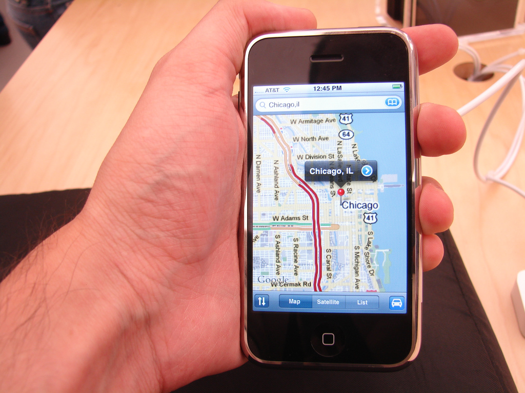
“If you’re a visual learner, then you know maps, charts and infographics can really help bring data and information to life. Maps can make a point resonate with readers and this collection aims to do just that. Hopefully some of these maps will surprise you and you’ll learn something new. A few are important to know, some interpret and display data in a beautiful or creative way, and a few may even make you chuckle or shake your head.” Check out these 40 amazing maps!
Rising Seas – If All the Ice Melted (NG)
5 Nov Check out this really cool map from National Geographic entitled Rising Seas – If all the Ice Melted. The maps here show the world as it is now, with only one difference: All the ice on land has melted and drained into the sea, raising it 216 feet and creating new shorelines for our continents and inland seas. Click on the maps from different regions of the world to see what it might look like in 5,000 years. Hmmm….where is Chennai?
Ostrich-Egg Globe May Be Oldest to Depict New World
22 Aug Washington Map Society
Washington Map Society
I saw this Interesting article on the History Channel website. According to the article, “Ostrich-Egg Globe May Be Oldest to Depict New World,” researchers believe the globe is dated 1504, and it’s the oldest yet to identify the New World (the Americas). The article states: “Thomas Sander, editor of the Portolan, points out that the egg might have been made for an Italian noble family around the time of famed artist Leonardo da Vinci, when the nobility often kept ostriches in their back gardens as one more sign of their wealth.” Finally, the Latin phrase Hic Sunt Dracones, translated as “Here be dragons” appears on the globe above the coast of Southeast Asia. I thought this was a great article, especially since we are learning about maps and how maps have changed over time. Click on the link to read the entire article.
National Geographic Education – click on this link to see a wide variety of maps.
Gorgeous Glimpses of Calamity
20 AugJan. 10, 2013: In this photo from NASA’s Aqua satellite, haze below the Himalayas blankets Northern India and Bangladesh, likely the result of fires, urban and industrial pollution, and a meteorological phenomenon called temperature inversion.
In class we have been learning about geography, climate, vegetation and the five themes of geography. One of the themes is human-environment interaction. I read an interesting article on the New York Times website about the damage that humans are creating and the effects on our environment. The article has some difficult vocabulary, but the videos and images are very good. Click on the hyper-link for the article, “Gorgeous Glimpses of Calamity,” if you want to see some really interesting images and videos. Mr. Martin
 Out of Eden Walk
- An error has occurred; the feed is probably down. Try again later.
Visitors since 9/27/13

This work is licensed under a Creative Commons Attribution-NonCommercial-ShareAlike 4.0 International License.

Recent Comments